Sigiriya, Sri Lanka
- Dec 1, 2025
- 9 min read

Dear Reader,
This past decade, I’ve lived in several places across South India. The teardrop-shaped country of Sri Lanka has been tantalisingly close. Yet it took a work trip for me to cross the Palk Strait (in a manner of speaking, as flights make the journey far less adventurous).
In college, while studying the history of cartography, it was fascinating to see the little island’s shape and name change across different maps. Greek and Roman maps, notably, Ptolemy’s 15th Century map, features ‘Taprobane’ as an oversized island, next to the tiny peninsula of India. Taprobane or Taprobana, was derived from the Sinhala word, Tamraparni, meaning copper-coloured leaves — often equated with the copper-coloured shores of Sri Lanka. Persian and Arab scholars knew of it as ‘Serendib’, a place which inspired a fairy tale of three princes who make fortuitous discoveries, giving rise to the word ‘serendipity’. During the colonial period, Dutch and British maps rendered the island as ‘Ceylon’, derived from ancient Tamil text references of silam or sailan. Today’s name stems from the 10th-12th Century texts which mention Lanka as the kingdom of King Ravana with Sri added as an honorific.
As much as I would’ve loved to retrace Sri Lanka’s history through the ages, I could only make time to visit the Central Province, defined by lush forests punctuated by rocky outcrops — with one incredible archaeological site that harks back to one of the island’s oldest names, Sihala or Sinhala, meaning lion’s abode.
In this blog, I’ll write about Sigiriya or Lion’s Paw, a palace-fortress perched atop a Precambrian inselberg, to peel back the layers of time from its geological origins, the prehistoric civilizations that lived in its shadow, to the 5th Century citadel that gave rise to its present-day status as a UNESCO World Heritage site.
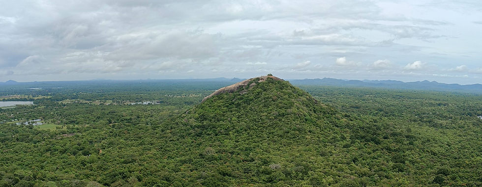
Sigiriya or Lion’s Paw, Central Sri Lanka
The day I landed in Sri Lanka, I took a cab straight from Colombo airport to Dambulla, a town that serves as a base for various points of interest: 1st Century Buddhist caves with paintings, the Minneriya National Park, best known for its elephants, and the Sigiriya rock fortress. From my resort balcony, Sigiriya and its neighbouring Pidurangala rock were little nubs on an otherwise flat horizon of farmlands. In the mornings, mellow sunlight cast a spell on the distant hilltops, and afternoons cloaked them in clouds or blurred their outlines with drizzle. In the evenings, the horizon smudged into velvet skies, and the twinkle of fireflies and stars was all I could see.

For a few days, as I explored the other sights, Sigiriya loomed in the distance. The better-known sites were a bit disappointing (for reasons I will not go into here). Yet I stumbled upon lesser-known, poorly-signposted ruins such as an unfinished stupa with an empty chamber, perhaps, for a religious relic, a many-pillared hall and an overgrown brick stupa where fire ants reigned — and I cast myself as an intrepid Lara Croft! Vivid imagination aside, these places indicate the rich potential of Sri Lanka’s archaeological sites and tell textured stories of prehistory and Buddhism.
On the third day, I made my way to Sigiriya. As a UNESCO World Heritage site, the entrance fees are a little formidable for foreigners, and a little less so for SAARC countries. Despite what several travel blogs and forums claim, the entrance fee is well worth it — after all, this isn’t just a 180 m (590 ft)-high rocky outcrop, there’s a palace, Buddhist rock paintings, a mirror-like wall, an intricate irrigation system, and walled gardens to marvel at! There’s also a museum in serious need of upkeep, but with some interesting artefacts and information.
The Geological History of Sigiriya
The Sigiriya outcrop has been dated to roughly 2.5 or 1.8 billion years and was formed in the middle Precambrian era. It is a classic example of an inselberg or mountain island, an isolated feature that rises abruptly from the surrounding plains, formed by the erosion of softer rock [I’ve written about Hampi’s inselbergs before]. Some sources indicate that Sigiriya isn’t like other inselbergs; it wasn’t formed when bedrock was exposed to the elements. Instead, it is the remnants of a volcanic plug — formed when magma solidifies in the neck or vent of a volcano, later exposed when the surrounding rocks are eroded. Yet I could find no research papers with this information — as with India’s inselbergs, clearly, more studies are needed.
The museum, however, had a profile image of the outcrop with details on the various strata. It comprises a capstone of quartzo-feldspathic gneiss, weathered layers with fold patterns, and a base of hornblende-biotite gneiss. In simpler terms, it indicates an initial volcanic layer that cooled deep underground, then underwent intense temperature and pressure and was metamorphosed into alternating light and dark bands. At some point, tectonic forces acted on these layers, causing them to crease and crumple into folds. Over the past million years or so, these ancient layers were exposed and weathered by rainwater, wind, and vegetation. The quartzo-feldspathic gneiss resisted weathering and formed a resilient capstone that preserved the layers beneath.
Inselbergs across the Indian subcontinent, too, are comprised of gneiss, a metamorphosed version of volcanic granite. This isn’t surprising when you consider that at the time the inselberg bedrocks formed, Sri Lanka and India were part of the Gondwanaland supercontinent. The two landmasses only broke away around 130 million years ago, during the Early Cretaceous period. While India drifted northwards, the teardrop-shaped island turned slightly anticlockwise to reach its current position.
Prehistoric Sigiriya
Several rock shelters and archaeological sites discovered around Sigiriya indicate that this area has been occupied since 8000 BC, or 10,000 years ago. Stone and bone tools, food residue of charred seeds, plants, animal bones and mollusc shells, and human skeletal remains from different time periods support successive human occupation of the region.

From 3000 to 1000 BC, archaeological studies support food gathering, hunting, the establishment of villages, the cultivation of rice and millets, irrigation, and also the production and use of iron. During my explorations, I visited the Ibbankatuwa megalithic tombs near Sigiriya. This megalithic site of tomb clusters has been carbon-dated to roughly 700 – 450 B.C. It is testimony to two burial rites prevalent at the time: urn burials, in which bodies were placed in urns and interred, and cist burials, in which only the ashes were buried. Interestingly, other grave items and tools were also unearthed, including iron, copper, gold artefacts, gems and beads, and jewellery. Some jewellery features gemstones that aren’t mined in Sri Lanka that whisper of ancient trade across the Indian Ocean.
From the 1st to the 3rd Century AD, iron production in the region expanded considerably, setting the stage for the rise of a city, or in this case, a citadel.
Sigiriya or Sinhagiri — where lions dare!
In the last quarter of the 5th Century AD, Sigiriya dramatically entered Sri Lanka’s political history. In a violent coup, King Dhatusena (459-477 AD)’s reign ended at the hands of Prince Kasyapa, his son born of a non-royal consort. Kasyapa was supported by the king’s nephew and army commander, Migara. The coup forced the crown prince, Moggallana, to take exile in India. Meanwhile, Kasyapa, knowing his claim to the throne was shaky and fearing reprisal from his half-brother, was advised to establish his capital at Sigiriya.
During Kasyapa’s reign, he constructed intricate stairways and galleries that clung to the sheer cliffside. At the base of the cliff, an elaborate network of water pavilions, marble-floored pools, courtyards, and water channels forms a miniature water garden — the work was carried out in several stages, with some completed after his reign ended. The landscaped boulder garden whispers of a 3rd Century monastic complex of thirty caves, some bearing Brahmi inscriptions, some with near-faded paintings of female figures, as well as a Bodhi-tree shrine and a stupa built at a later period.
The path leads upwards, past a boulder-framed arch, stone-carved drains, brickwork recesses with miniature Buddha statues — the ancient brickwork bearing the brunt of modern metal staircases.

Halfway up, the Lion’s Paw Terrace, with colossal stone-carved paws set in brick masonry, serves as a gateway to the palace above — the lion appears to be in a crouching position, with its front paws, head, and shoulders emerging from the rock. Some remnants of moonstones and guardstones etched in limestone, and a stairway, indicate that the site was far more elaborate in the recent past. Records claim that a sculpted lion’s head led to the uppermost section, but it collapsed years ago. The master builders and the king gave the site its present name, Sinhagiri or Lion Mountain — perhaps, inspired by Sri Lanka’s ancient name, Sihala or Sinhala, meaning lion’s abode.

At the top lies a palace complex, with an outer/lower palace and an inner/upper palace separated by a marble-paved walkway that leads to the east-facing ceremonial throne and the palace gardens. The brickwork reservoirs still capture rainwater and must have once sustained the citadel’s residents. As an art connoisseur, Kasyapa commissioned a gallery with Buddhist frescoes, situated below a natural overhang. Leading to the gallery was a plastered wall polished to a mirror-like finish, where Kasyapa could see his reflection. During Kasyapa’s 18-year reign, visitors to the famed gallery left graffiti and scribbles along the passage, some of which have been dated to the 8th - 10th Century AD. The scribbles feature over 1500 poems, most celebrating the beauty of the women in the frescoes, and some random verse.

During Moggallana’s exile, he gathered forces and eventually returned to Sri Lanka. While constructing the citadel, Kasyapa’s soothsayers had claimed that he’d be safest on the clifftop. Yet if he ever returned to the plains, his half-brother and crown prince would kill him. This prophecy caused Kasyapa to stay at Sigiriya while Moggallana’s forces laid siege to the base. For a while at least, Kasyapa was safe high in his palace-fortress. It is said that Moggallana started sending incendiary messages about Kasyapa’s mother. Enraged, Kasyapa asked for his war elephant to be readied, ignored the warnings from his advisors and rode out to meet Moggallana’s forces. The ancient chronicles mention that Kasyapa’s forces fled without putting up a fight. Then Kasyapa pulled out his dagger, cut his own throat, and raised it high before sheathing it in his scabbard.
When Moggallana assumed power, he shifted the capital back to Anuradhapura, and monasteries were established at Sigiriya and the nearby Pidurangala and Ramakale rocks. Sigiriya’s monastic period lasted until the 13th or 14th Century, after which it disappears from historical records, to briefly surface as a distant military outpost in the 16th to 18th Century.
It wasn’t till the 19th Century that researchers took an interest in Sigiriya and began piecing together its history. In 1894, the archaeological department led the investigation, restoration & conservation work, which culminated in the UNESCO World Heritage Site inscription in 1982. Today, Sigiriya is among many granite-based natural landscapes that feature in the UNESCO Heritage list, meeting the criteria of ‘contain superlative natural phenomena or areas of exceptional natural beauty and aesthetic importance’.
Yet today, as you scale the sheer sides of Sigiriya — a fortress now claimed by marauding troops of toque macaques, and look out over the lush-green valleys — try to imagine an entire city, complete with palace intrigues and political ambitions, perched atop this rocky outcrop. More than a monument, this complex is a marvel of engineering and sheer human will that eventually succumbed to the merciless tides of Time.
For 80s music fans, especially if you were tuned to music videos, Sigiriya may seem vaguely familiar — it is featured in Duran Duran’s Save a Prayer:


