Cartography: India
- Nov 29, 2021
- 7 min read
Updated: May 10, 2024

What is cartography? Simply put, it is the science and practice of drawing maps. Imagine this, the Earth is spherical (unless you're a flat-Earther!) and yet we have long tried to depict its features on a two-dimensional, flat surface. Hence, every map cannot be completely accurate, and will be distorted - as some cartographers say, every map is a lie. Yet the grains of truth contained within a map are beautiful, visual, and tell many stories - if we know how to decipher it. Interestingly, maps have a language of their own: symbols, directions, scale, and detail (of the geographical or political divides, or for any other purpose a map may serve).
Yet the definition of maps hasn't always been so. Over time, maps served different purposes, hence, they evolved from pictorial or artistic renditions to the more accurate, digital, scalable versions today. In this piece, I hope to explore the cartographic traditions of India - in the context of South Asia, and will cover some examples of interesting maps that helped shape our understanding of the geographic, political, and demographic divides.
PRE-EUROPEAN ERA Indus Valley civilization (~3300 BCE) - arrival of Vasco da Gama (1498 CE): Fewer ancient or medieval maps have been found from South Asia than from East Asia and the Islamic lands in Middle East. Here, South Asia implies the Indian subcontinent, Nepal, Pakistan, Bangladesh, Sri Lanka, some parts of the Tibetan Autonomous region, as well as Thailand, Laos, Cambodia, Malaysia and most of Indonesia. For India, with its major contributions to the fields of astronomy, mathematics, geometry, and its historic empires and dynasties, the paucity of old maps comes as a big surprise. Perhaps India had created maps before the arrival of the Portuguese, yet little of its ancient cartographic tradition survives to date. Potsherds from the 2nd or 1st BCE with rough plans of monasteries, classic paintings and a few sculptures depicting sacred rivers, such as at Udayagiri (400 CE), Andhra Pradesh are some evidences of early cartography. The Jain bas-relief (above) dated no earlier than 1199-2000 CE, shows a representation of the mythical continent NandIsvaradvlpa, but isn't considered cartography by modern definitions.

Aḍhāī-dvīpa - the title means two and a half continents and represents the Jain universe. The outermost yellow circle represents the mountain range, Manuṣottara - beyond which humans cannot live, the two blue circles represent two oceans - Lavaṇa Samudra or ‘Salt Ocean’, and Kālodadhi or ‘Black-Water Ocean’, and the entire diagram represents the middle world. The spaces within these three circles form the human world, Aḍhāī-dvīpa (Two and a Half Continents), the only part of the Jain universe where the soul can achieve liberation from the constant cycle of death and rebirth.
Geographical locations were often mentioned in the epic poem, Ramayana, and Bhavabhuti's Uttararamcarita, yet neither of these can be considered as 'cartography' in its truest sense.
Some written records, indigenous and foreign, allow researchers to infer some ideas about cartography (and cosmology - a study of the chronology of the Universe) from pre-European times. Lamentably, general histories of cartographies from across the world fail to acknowledge or include South Asian maps.
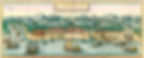
A view of Calicut (Kozhikode) city by Braun and Hogenburg,1599. While he map was created after the Classical Antiquity era, it represents what might have been Vasco da Gama's first view of the Malabar coast when he landed in 1498.
CLASSICAL ANTIQUITY AND THE MIDDLES AGES Civilizations around the Mediterranean (8th BCE - 6th CE) - arrival of Vasco da Gama (1498 CE): While indigenous maps have not survived, India was often depicted in maps used by ancient Greek and Roman traders, or created by Islamic and Italian scholars, and later by Portuguese navigators. Though these ancient maps seem rather inaccurate, with proportions between places askew, studying them allows us understand India's place in global trade and economy over the years. And more importantly, how the world's understanding of India evolved over the years. Oddly, Ptolemy's map shows the Indian Ocean as a closed body of water, with a greatly exaggerated Sri Lanka (known as Taprobane then), and a distorted, tiny peninsula of India. The Iranian geographers Abū Muhammad al-Hasan al-Hamdānī and Habash al-Hasib al-Marwazi aligned the prime meridian of their maps - the 0° latitude, to the city of Ujjain, the centre of Indian astronomy at the time. In the early 11th CE, Abu Rayhan Biruni, a Persian geographer, visited India, to study its geography, and was most skilled in mapping cities in the western Indian subcontinent and measuring the distances between them. He also wrote extensively on the geology of India. In 1154, the Arab geographer Muhammad al-Idrisi added a section on the cartography and geography of India and its neighboring countries to his world atlas, Tabula Rogeriana.

A map of the world published in the Tabula Rogeriana by Arab geographer Muhammad al-Idrisi. If the map seems strange and unfamiliar, it is perhaps because the map has south at the top, in traditional Islamic style rather than the north orientation used by modern map conventions.
In his magnum opus La Cartografia Antica dell'India, the Italian scholar Francesco Lorenzo Pullè reproduced a number of Indian maps, some of which were sourced from the manuscript Lokaprakasa, originally compiled by the polymath Ksemendra (Kashmir, 11th century CE), and the Laghu Samgrahani Sutra (a 12th CE Jain text on cosmology).
THE PORTUGUESE-MUGHAL-DUTCH ERA
The arrival of Vasco da Gama (1498 CE) to the establishment of the East India Company (~1612 CE)
After Vasco da Gama reached Calicut (or Kappad, to be precise, located 25 kilometres away), off the western coast of India, the Portuguese mapping of the Malabar Coast, and the other parts of the subcontinent accelerated. In just a few decades, maps of India were widely available and copied for the use of navigators across the world, notably in the Cantino planisphere - a 1502 world map named after an agent of the Duke of Ferrara, Alberto Cantino, who smuggled the map from Portugal to Italy. Other developments in cartography continued, with contributions from Portuguese, Mughal, Dutch and other European players.
In 1590, the Mughal administrative text, Ain-i-Akbari referenced older Indian cartographic examples. Around the same time, Mughal metallurgists were rediscovering the art of lost-wax casting - where replicas of metal sculptures could be created by melting them into wax moulds. This ancient casting technique was then used to create seamless, hollow globes depicting celestial bodies - and in the late 1900s, was repurposed to depict world maps. In late 1600s, the Mughal scholar Sadiq Isfahani compiled a 32-page atlas of parts of the world he deemed 'suitable/fit for human life' - the collection bore maps oriented to the south rather than north (as we are today used to), true to the Islamic tradition.
The 16th CE was also marked by European explorers who ventured beyond the trading ports across the Indian subcontinent, and refined the navigational charts with greater detail. In 1596, The Dutch merchant, trader and historian, Jan Huygens van Linschoten, published a series of works in his 'Itinerio', which allowed Europeans to view the East Indies, and particularly India, in lurid detail.

A bird's eye view map of Goa from Linschoten's Itinerario. For those who are familiar with Goa, the islands (ilhades) of Divar, Chorao, Narve, and smaller features like Reis Magos fort, and the outer margins of Bardez and Salcete, will indicate just how detailed this map is.
THE BRITISH ERA
The establishment of the East India Company (~1612 CE)to India's Independence (1947 CE)
The British Raj saw the first-ever formally appointed cartographer under the British Survey of India, in 1767. The 19th CE saw the ambitious Great Trigonometric Survey, started by William Lambton, ending with George Everest - an undertaking that achieved many cartographic feats using simple trigonometry (I always thought school trigonometry was rather pointless - now I know better!).
It was the most accurate measurement of the curvature of the Earth to date, and calculated the gravitational influence of mountains via pendulums. The maps also estimated heights above sea level for most locations.
Several mapping expeditions were undertaken to map Tibet, and China, with teams of Indian cartographers like Mohamed-i-Hameed, Mani Singh, and Nain Singh. In 1876, Nain Singh went on to receive the Royal Geographical Society's gold medal for his contributions to Asia's geographical knowledge.
THE MODERN ERA
India's Independence (1947 CE) to present day
After India's Independence, the government soon realized the economic importance of exploring and mapping its natural resources. To this end, in 1949, the Central Board of Geophysics (CBG) was established, and headed by the geophysicist-in-charge of the Geological Survey of India (formely the British Survey of India). The CBG branched out into the Geophysical Research Wing in Kolkata, and the Oceanographic Research Wing in Kochi, to study the landmasses and oceans respectively.
Later, under the aegis of the Council of Scientific and Industrial Research (CSIR) transformed into the National Geophysical Research Institute (CSIR-NGRI), Hyderabad, and the CSIR-National Oceanographic Institute (CSIR-NIO), Goa.
Other mapping agencies include the Survey of India (SOI), and the National Atlas and Thematic Mapping Organization (NATMO) - responsible for a range of maps for industrial, political, and educational purposes.
MAP RESOURCES

India Orientalis, 1623. Authors: Mercator, Gerhard, Hondius, Jodocus, and Hondius, Hendrik. Published by Hendricus Hondius. Browse this map in detail via the David Rumsey Map Collection.
DAVID RUMSEY'S MAP COLLECTION
Housed at the Stanford University Library, the David Rumsey Map Collection is an incredible resource with over 110,00 maps and other images from 16th - 21st CE. Apart from a exhaustive range of aerial photos, nautical charts, celestial and maritime maps, data visualizations, most maps have been georeferenced - as in, you can browse them as overlays to modern, digital, zoomable maps without losing the detail. You can also download the maps at different resolutions!
COSMOLOGY TO CARTOGRAPHY
A Google Arts and Culture story, by Kalakriti Archives, Hyderabad
This cultural journey of Indian maps charts the evolution of maps from cosmology to navigation, and city planning - with rich notes on the colonial legacy, and a beautiful selection of maps.
ONLINE EXHIBIT: MAPS AND MAP-MAKING IN INDIA
An online exhibit of European maps of India, with some Mughal examples curated as part of the “India in the World” College of Literature, Science, and the Arts (LSA) Theme Semester ( January 16 - April 22, 2014). This was the online version maintained after the physical exhibition was wrapped up, with material largely sourced from the public domain.